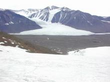
The Canada Glacier a small glacier flowing south-east into the northern side of Taylor Valley. The glacier receives less than 10 cm of snowfall annually. Its seasonal melting feeds Lake Hoare to the west and Lake Fryxell to the east.
The Canada Glacier terminus cliff meteorology station was set up on the terminus cliff portion of Canada Glacier. An area was chosen where the ice begins to get fairly rough. Latitudes and longitudes are unavailable at this time. - station no longer in use ID: CTRM
Snowpit was excavated in the accumulation zone of the Canada Glacier during the 2000-2001 austral summer. GPS coordinates were not obtained at the time of sample collection. Location is approximated based on the recollection of Thomas Nylen, and provided by Kathy Welch in October 2022.
Canada Stream at delta ID: canada_delta Coordinates based on averaging the starting and ending points of the 'Canada stream at delta' transect (measurements are occasionally made in middle of the established transect) Provenance : StreamsIC-97-98_ques.txt
Coordinates taken from 1996-97 GPS measurements at center of creek where it enters Lake Fryxell
Parent Stream: Canada Stream
Provenance : GPS96-97.DOC
ID: canada_mouth